Distance: 5.5 miles (one way)
Type: Out and back
Difficulty: Strenuous
Kid-friendly: No
Dog-friendly: No
Water: Yes
The Amphitheater Lake Trail is the most challenging of the most popular hikes in the Tetons. While many casual hikers will check out Inspiration Point and Taggart Lake, experienced hikers don’t mind the 3,000 foot elevation gain to a spectacular alpine mountain lake.
Note: Both grizzly and black bears are frequently seen along this trail. If you’re petrified of either, please educate yourself on the actual dangers that bears pose. It is not necessary to blare music while on the trail, nor is it appreciated by anyone else within a half-mile radius of you. Talking at a normal volume with hiking partners is enough to scare bears away. If one has heard you and is still nearby, it doesn’t mind you walking by, as long as you respect it and continue on your way.
View more images available as prints from Grand Teton National Park
Amphitheater Lake Trail Description
The magnificent ascent up to Amphitheater Lake begins at the Lupine Meadows Trailhead, just south of Jenny Lake. The trail is found at the far end of the parking area and immediately enters into an old forest of lodgepole pine, spruce, and fir. It’s a flat stroll for the first 0.25 miles as the trail bends around the southern edge of Lupine Meadows. Early morning or evening hikers along the trail may be able to spot some elk grazing in the meadow. The trail then makes a sharp turn into the old growth evergreen forest, consistently climbing past boulders brought down from high in the mountains by glaciers from previous ice ages. It’s a still and silent forest that is soon broken up by the sound of a distant creek. As you continue hiking, you pass over a small wooden bridge that carries you over the milky waters of Glacier Gulch, which is fed by the sublime Delta Lake, a lake directly fed from Teton Glacier thousands of feet above you.
You’re then brought to a series of meadows that break up the forest as you traverse along a glacial moraine, house-sized boulders being the evidence of that. Then, at one mile in, you reach a 90 degree turn in the trail, bending west toward the Teton Mountains. Continuing up the trail, you then begin a steady and moderately steep ascent up the ridgeline of the glacial moraine. While a thick forest obstructs any views to the right, you’ll notice a pleasant meadow far below on your left. The trail then skirts the north side of the ridgeline, eliminating the views as you climb steadily through the forest, until you reach a junction with the Valley Trail at 2.2 miles in. The Amphitheater Lake Trail continues straight ahead, heading up the mountainside.
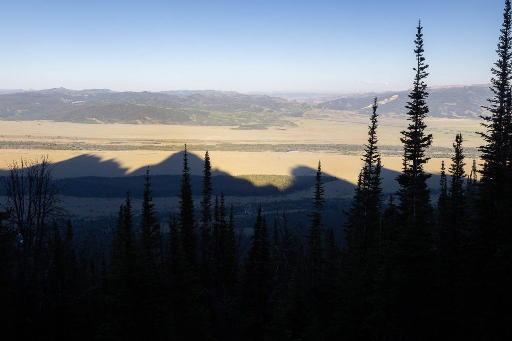
It’s a steady ascent switchbacking up the eastern face of the Teton Mountains. Depending on the time of year, you’ll cross a couple of trickling streams into vast meadows of mule’s ear wildflowers carpeting the steep mountainside in a golden blanket. Ahead of you on the trail, wildflowers give way to old forests, which give way to meadow after another old forest. The pattern persists as you climb steadily higher up the side of the Tetons, all the while the views looking back east over the valley of Jackson Hole becoming ever more spectacular. Taggart and Bradley Lakes become easily visible far below at the base of the mountains. You’re finally brought to another junction at 3.5 miles in, left bringing you to Garnet Canyon, while right leads you on to Amphitheater Lake.
From here as the meadows get smaller, so do the switchbacks, but the ascent never lets up. You climb yet higher still through the smaller meadows, as very soon you begin to notice the endangered whitebark pine, a sign of achieving significant elevation gain over the trailhead far below. The forest at this point begins to thin out a little and the switchbacks become noticeably shorter. The occasional view to the north and east can even be enjoyed from time to time as you climb deeper into the ridge. After the switchbacks become quite rocky, the trail finally flattens out as you wind past a small pond, cutting directly to the west around it. Following the trail for a short distance more, you’re greeted with views of Surprise Lake just off to the left. (Surprise! There’s another lake.)
Note: There has been a lot of unnecessary trampling and erosion from people shortcutting the trails in the area. Please respect the park’s efforts and the trail system and stay on the trails. You just climbed a mountain. Is it really worth trying to save a few steps at the expense of the native vegetation?
A quick 0.1 mile detour will bring you down to the lake’s shores where you can explore around its perimeter and (if you want) peer over the rocky ledge to the south over the valley, now thousands of feet below. When you’ve enjoyed your time at Surprise Lake, head back to the main trail and continue on for another 0.2 miles through the forest to finally reach Amphitheater Lake.
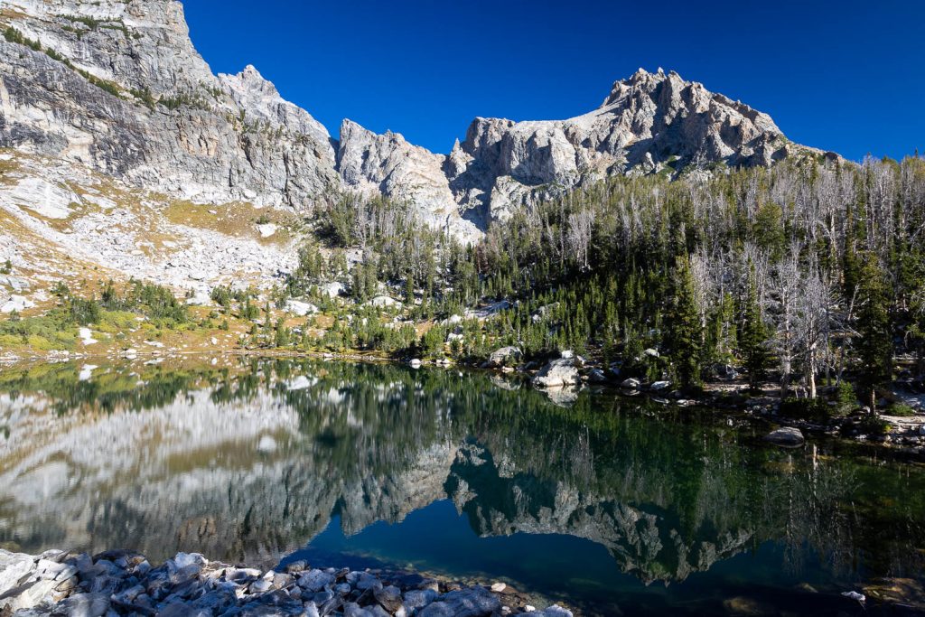
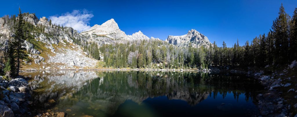
As you crest the final ridge, Amphitheater Lake and its surrounding mountains open up in front of you in a 180 degree panoramic view. The lake shimmers reflections of the Grand Teton beyond it, and the more obscurely hidden Disappointment Peak directly above. You’re encouraged to walk around its perimeter getting in as many great views as you can. Unofficial trails will also lead to different areas. A trail on the south side of the lake will lead to the ridge directly to the south of the lake, while proceeding west on that trail will bring you up to Disappointment Peak, for those looking to add a little climbing and scrambling to their hike. Heading north you’ll climb a small divide that brings you to the top of Glacier Gulch, directly across from Teton Glacier. In other words, there are no bad views or wrong turns to make up here. This is why it’s such a popular hike.
Once you’ve enjoyed the views and the area, head down the same way you came in. If you’re there in the afternoon, make sure you allow for enough time to get down safely.
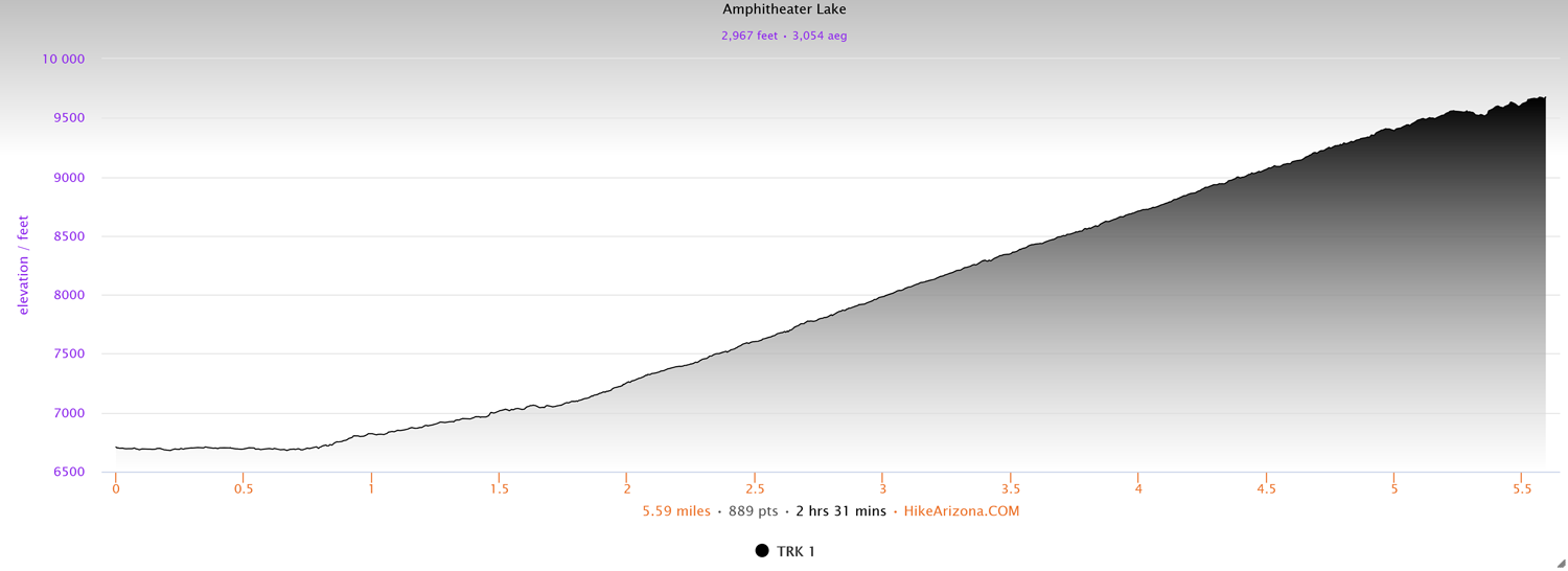
Elevation and route courtesy of Route Scout
Getting There
From the Grand Teton National Park Visitor Center, head west to the Moose Entrance Station and proceed north along the Teton Park Road (aka, the Inner Park Road) for 6.5 miles until you reach the Lupine Meadows Trailhead turnoff on your left. Follow that road a short distance, then cross over Cottonwood Creek. The road splits immediately after the bridge, where you’ll want to head left, then there’s another fork immediately after that, where you’ll want to stay right. Continue down the main road and it will dead end at the parking area.