
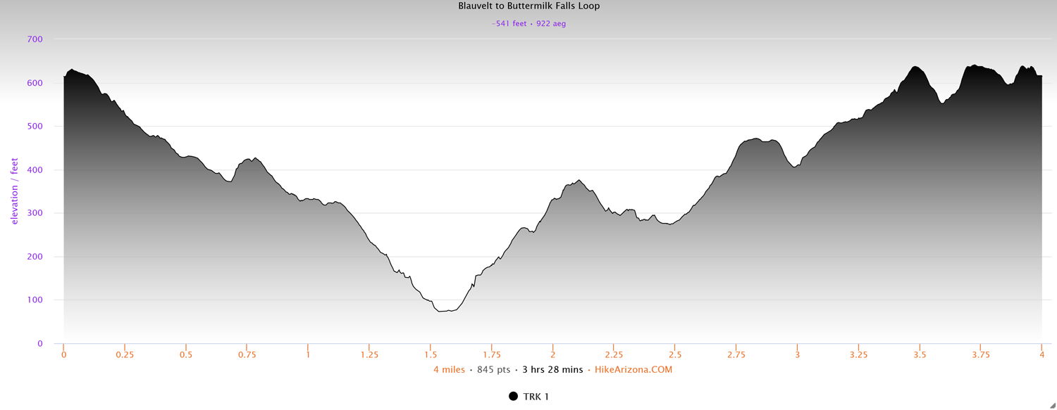
Distance: 4 miles
Type: Loop
Difficulty: Moderate
Kid-friendly: Yes
Dog-friendly: Yes
Water: Yes
Blauvelt State Park, perched atop the Hudson River Palisades in the lower Hudson Valley, often goes largely overlooked, as does its neighbor, Buttermilk Falls County Park. By using trails that connect through both parks, as well as other smaller neighboring town and county parks, an enjoyable loop can be connected that features a 30 foot waterfall, plenty of elevation change, gorgeous overlooks, and even a couple of miles of the Long Path.
The obvious location to park for this loop would be at Buttermilk Falls County Park, however on this occasion, I found a small parking area on the shoulder of the road in Blauvelt State Park. I always find it adds a sense of wildness to a trail when you can continue hiking directly through a main parking area or developed section, something this loop does more than once.
View more images available as prints from New York
Blauvelt State Park and Buttermilk Falls Loop Description
From the small parking area on the shoulder of the road, backtrack up the road for 0.1 miles to access the red blazed trail. After a quick ascent into a small meadow, the trail leads you down into the dense forest along a small ridge. You’ll find the trail to be a little overgrown in some places, though it’s here that the road noise temporarily fades away, inspiring a bit more of a wildness from the trail.
You’ll soon reach a connection with the white trail, where you’ll proceed right, continuing past a large glacial boulder also on the right. The trail will flatten out as it widens, seeming to invite the now distant road noise back in.
Continue past a junction with an unmaintained trail where you’ll quickly come to a road crossing. Look for the trail to resume on the other side of the road where it leaves Blauvelt State Park and enters Schuyler Town Park. A short distance from the road, the trail will fork off to the left, ascending a relatively steep hill for a short distance. At the top, a small spur will lead off to the left while the white trail continues to the right. As you’re led down the hill through some diverse vegetation, you’re soon brought to another road crossing, marking the boundary with Buttermilk Falls County Park.

After crossing the road, you’ll cross over a small footbridge before skirting along a small ridge. Continue through the beautiful forest to connect up with an old dirt road, bringing in more road noise from a highway below. At the junction with the blue trail, stay on the white trail by continuing straight. Toward the bottom of the descent on the dirt road, maintain the white trail by forking off to the right. A quick and easy scramble through a bit of rocky terrain will bring you to another small footbridge below large rocky cliffs rising up on your right. This brings you to the main parking area for Buttermilk Falls County Park. Pick up the blue trail on the other side of the parking area where it will immediately begin ascending a hill. A rocky scramble here and there past gorgeous geologic samples ultimately brings you up to the top of the hill, past an old fork in the trail that’s being left for nature to recover. Depending on weather from the past day or so, you may or may not hear the sound of water pouring over a cliff.
At dry times, Buttermilk Falls is simply a healthy trickle down the geometric rocky slabs. With more rain or melting snow, it’s a beautiful pouring of water streaming over the charcoal gray rocks. In winter, it’s a fantastic ice sculpture clinging to the cliffs. The overlook is situated above the falls, and it’s recommended you not test fate by venturing below, so use your best judgement in the area, especially if the ground is wet.

At the top of the falls, easy access to the creek provides an ideal location to relax. Geometric patterns in the rocky creek bed invite a curious mind to stop and admire, or to simply rest among a picturesque natural setting. Again, use caution at the top of a waterfall. Don’t ignore common sense.
Continuing ahead with the trail, you’re quickly led away from the creek and the waterfall to continue an ascent back toward the top of the eastern side of the Palisades. The rocky trail provides some nice natural stepping stones as you’re brought up to a small overlook that peers out to the south. Another brief but steep ascent over a rocky slab shows off an even better view, a panoramic vista looking out toward the western horizon, the mountains and forests of northern New Jersey far in the distance.
After one last climb for the moment, a junction with the orange trail can be found on your left as you head back into the woods. Follow this trail for a short distance and after crossing a small stream that’s done its share of eroding, you’ll find yourself at what appears to be a dead end at first glance.
The trail will have brought you up to a road, bordering the park with a residential neighborhood with the other side of the trail nowhere in sight. To find it, cross the road and head beyond the large sign on the opposite side of the road reading, Welcome to Central Nyack. There you’ll see the trail resuming between two properties. Please respect their privacy as you briefly pass through, and follow the trail as it drops down a steep hillside over a dozen feet or so. A fenced in area keeps out unwanted visitors to a storm water drainage area as the trail follows the perimeter of the fence for a brief section. The trail can be overgrown in this area during summer and fall months, and will also be muddy after rains or snow melt. The orange trail will end as it meets up with the white trail at a corner of the fence. Continue left along the white trail, as it will cross a rather eye-catching stream on the right before gradually beginning a steepening climb.

The fence and trail soon enough part ways as you’re finally led back into the forest. Here you enter the Sean Hunter Ryan Memorial County Park. At the top of the climb, you connect up with the Long Path, where you’ll head right to begin making your way back toward Blauvelt State Park. Along the way, an old bench is soon passed, perched off to the left on top of a hill, overlooking a view that was probably more inspiring when the bench was installed.
Follow the trail as it begins heading downhill to the right of a private residence. It will bring you to another road crossing, where you’ll pick up the trail on the opposite side, and be back in Blauvelt State Park. Here you’ll steadily climb a small hill, leaving the road noise behind once again, though it will resume from time to time.
You’re soon popped out high above the Hudson River where a beautiful break in the forest can be greatly appreciated. From here, the Long Path will make frequent short ascents and descents as it bobs up and down small rises along the trail, revealing quiet corners of the woods. After crossing a maintenance road, you’ll notice the trail paralleling the same road you parked on, making a steep climb up toward the original trail crossing you initially accessed. At the top, the red trail will fork off to the right, while the Long Path will pursue its course to the left.
If you have a little bit left in you, a great end to the trail can be found just a short distance down the Long Path from the junction. A beautiful overlook provides panoramic views to the east and west, giving visitors a great sense of accomplishment. Unfortunately, given its easy access, it’s also visited from less intelligent people who have left considerable litter around the graffitied rocks. Enjoy the view, and then head back to the red trail to be brought back to the road when you’re ready.
Elevation and route courtesy of Route Scout