
Distance: 14.25 miles
Type: Loop
Difficulty: Strenuous
Kid-friendly: No
Dog-friendly: Yes
Water: Yes
The Cache Creek to Skyline Trail Loop is a fantastically beautiful and strenuous 14.25 mile hike in the Gros Ventre Mountains, easily accessed from Jackson, Wyoming. The hike begins through a lush and popular canyon, ascending up to a long and wildly scenic ridgeline to round out the loop.
View more images available as prints from the Gros Ventre Mountains
Cache Creek to Skyline Trail Loop Description
The Cache Creek Trail system is a large web of trails that run along canyon. There are numerous ways to reach any destination in the area, but for the sake of not convoluting this post, we’ll stick to the main Cache Creek Trail.
Cache Creek Trail
Begin at the Cache Creek Trailhead and head up the wide and easy main trail. The old dirt road winds along the canyon bottom, never veering far from Cache Creek. You’ll pass through exquisite old forest while also occasionally popping out into a lush meadow lined with picturesque mountains. Along the way there will also be numerous junctions. Continue straight on the main trail through each one.
At roughly 2 miles in, the trail will begin to narrow and the old dirt road will begin to morph into a more standard single-track trail. You’ll also notice at this point that there are less people along the trail this far back. At 2.25 miles in, you’ll reach a junction with both the Putt Putt Trail and the Hagen Trail, each of them ending at this point. Optionally, you could take either one to this point, though they will add a bit of extra mileage.

The Cache Creek Trail maintains its course through dense old growth forests and an occasional meadow, the creek always nearby. At 4 miles in, you’ll reach a junction with the Game Creek Trail on the right. Head up that route to ascend toward the Skyline Trail.
Game Creek Trail
On the Game Creek Trail, you’ll cross Cache Creek before snaking through the woods, where you’ll begin the ascent. Also note that this will be your last opportunity to refill water for the remainder of the hike. Initially, the climb is pretty steep as it heads up through forests and meadows. You’ll reach a great overlook looking down Cache Creek Canyon as the trail begins to level out for a bit.
The Game Creek Trail will continue a steady but easy climb. The hiking is quite nice through this part as you begin to approach the next junction. At 4.6 miles in, you’ll reach the junction with the Skyline Trail. Head right to begin heading up.

Skyline Trail
Initially, the Skyline Trail is an easy meander through a small forest grove and a large meadow. Gentle switchbacks climb up the mountainside with great views of Cache Creek Canyon and the Game Creek drainage unfolding below. Continuing up the easy ascent, the forest begins to thicken with gorgeous views still visible through the trees.
Climbing steadily upward, the forest thickens a bit more while growing more lush higher up the switchbacks. After a bit of steepness in places, there will be a junction with a short spur trail known as the Viewpoint Trail at 6.1 miles in. At less than 0.25 miles round trip, it’s highly recommend you take it.
This stunning overlook provides dramatic vistas of Game Creek and the surrounding landscape below. To the east, the saddle you just climbed from is dwarfed below the large mountain just beyond. If you’re so inclined, this makes for a great snack break.

Back on the Skyline Trail, you’ll wind along the north side of the crest through a thick old forest. The mostly level trail provides an occasional glimpse into the canyon below through the trees.
You’ll soon make a noticeable descent. This is soon followed by a noticeable ascent back upward. Shortly thereafter, the Teton Mountains become visible through the trees. At this point, you’ll begin to climb back up toward the crest of the ridgeline.
Cresting the rugged ridgeline, you’re now treated to incredible views looking south. The Skyline Trail winds across the crest and the large meadow spread out across the top. You’ll drop down along the south side of the crest with beautiful views seeming to go on forever. The trail winds around the sparsely forested south side with even bigger views opening up to the west and southwest.

You’ll soon drop down to another saddle before taking switchbacks up to the crest once again. Along the way are still the nonstop gorgeous views. Soon those views are interrupted as you head down the north side of the ridge through an old forest. Switchbacks guide you down where you pop out into a meadow at a junction with Ferrin’s Trail at 11.1 miles in. Though the Skyline Trail continues straight, for the sake of this loop, head right onto Ferrin’s Trail.
Ferrin’s Trail
Ferrin’s Trail begins making large switchbacks downward as it approaches the forest. Before reaching the forest, you’re treated to outstanding views looking to the north. The Teton Mountains rise dramatically out of the northwest while the valley of Jackson Hole stretches far into the northern horizon.

Descending into the forest, you’ll drop down along large switchbacks that wind back and forth through the old mature woods. You’ll make a consistent descent along the serene switchbacks for 2 miles. At 13.1 miles in, you’ll reach another junction with the Sink or Swim Trail.
Connecting the Final Trails
Head right onto the Sink or Swim Trail for 0.4 miles. The next junction will be with Lloyd’s Cut. Take that left for its duration of 0.1 miles. The next junction will be with the Hagen Highway, where you’ll want to head right. Follow that where you’ll begin to hear the rush of Cache Creek once again. Stay on the Hagen Highway as it passes through two more junctions, which will ultimately cross over Cache Creek and pop out along the Cache Creek Drive just a few dozen yards west of the main parking area.
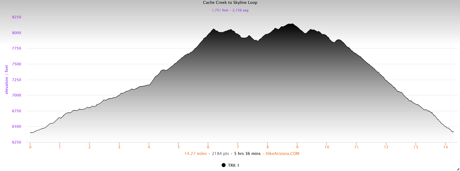
Elevation and route courtesy of Route Scout
Getting There
From downtown Jackson, head east on Broadway Ave. for 0.6 miles. Turn right onto Redmond Drive. Follow that for 0.4 miles and turn left onto Cache Creek Drive. Follow that until it dead-ends at the large parking area.