
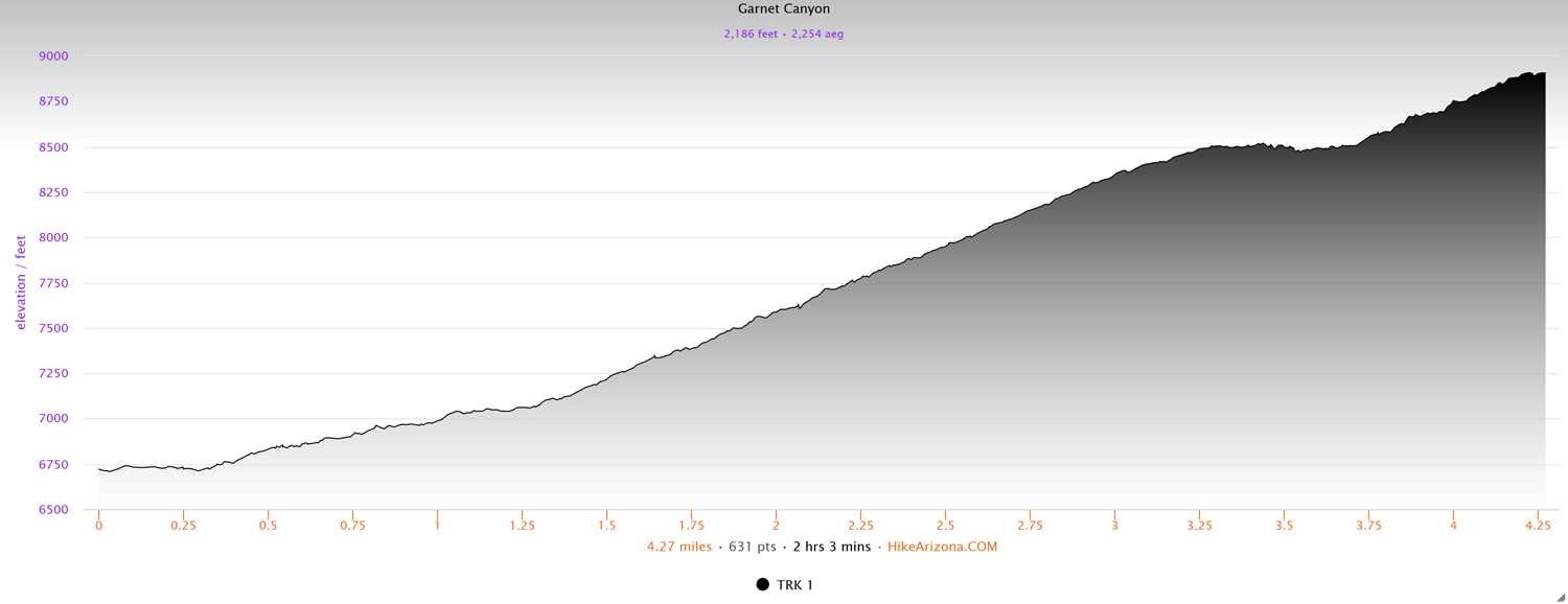
Distance: 4.2 miles (one way)
Type: Out and back
Difficulty: Strenuous
Kid-friendly: No
Dog-friendly: No
Water: Yes
The Garnet Canyon hike in Grand Teton National Park is a strenuous 4.2 mile (one way) trail that optionally continues farther up to the Lower Saddle and beyond. As you enter into Garnet Canyon, you’ll have unparalleled views of the Middle Teton straight ahead, with Nez Perce ahead and to the left. While the “official” trail ends at a junction for the Platform Campsites at 4.2 miles in, you can optionally continue up and over a large boulder field where jaw-dropping views of the previous two peaks plus the Grand Teton and Disappointment Peak tower around you.
View more images available as prints from Grand Teton National Park
Garnet Canyon Trail Description
For the initial 3.5 miles, the trail is the same route up as the popular Amphitheater Lake Trail, so you may experience a bit more traffic on the trail until the fork for Garnet Canyon.
From the Lupine Meadows Trailhead, head up the trail at the end of the parking area where you’ll enjoy an easy hike through the forest for the first 0.25 miles. From there, you’ll begin ascending the glacial moraine at the base of Glacier Gulch. Continue ascending around the moraine and at around 0.8 miles in you’ll come to a pair of scenic vistas overlooking Jackson Hole, after which the trail cuts directly inward toward the Teton Mountains. It will keep climbing the crest of the moraine and at 2.2 miles in you’ll reach a junction with the Valley Trail. The Valley Trail descends left while the Amphitheater Lake Trail continues upward straight ahead.
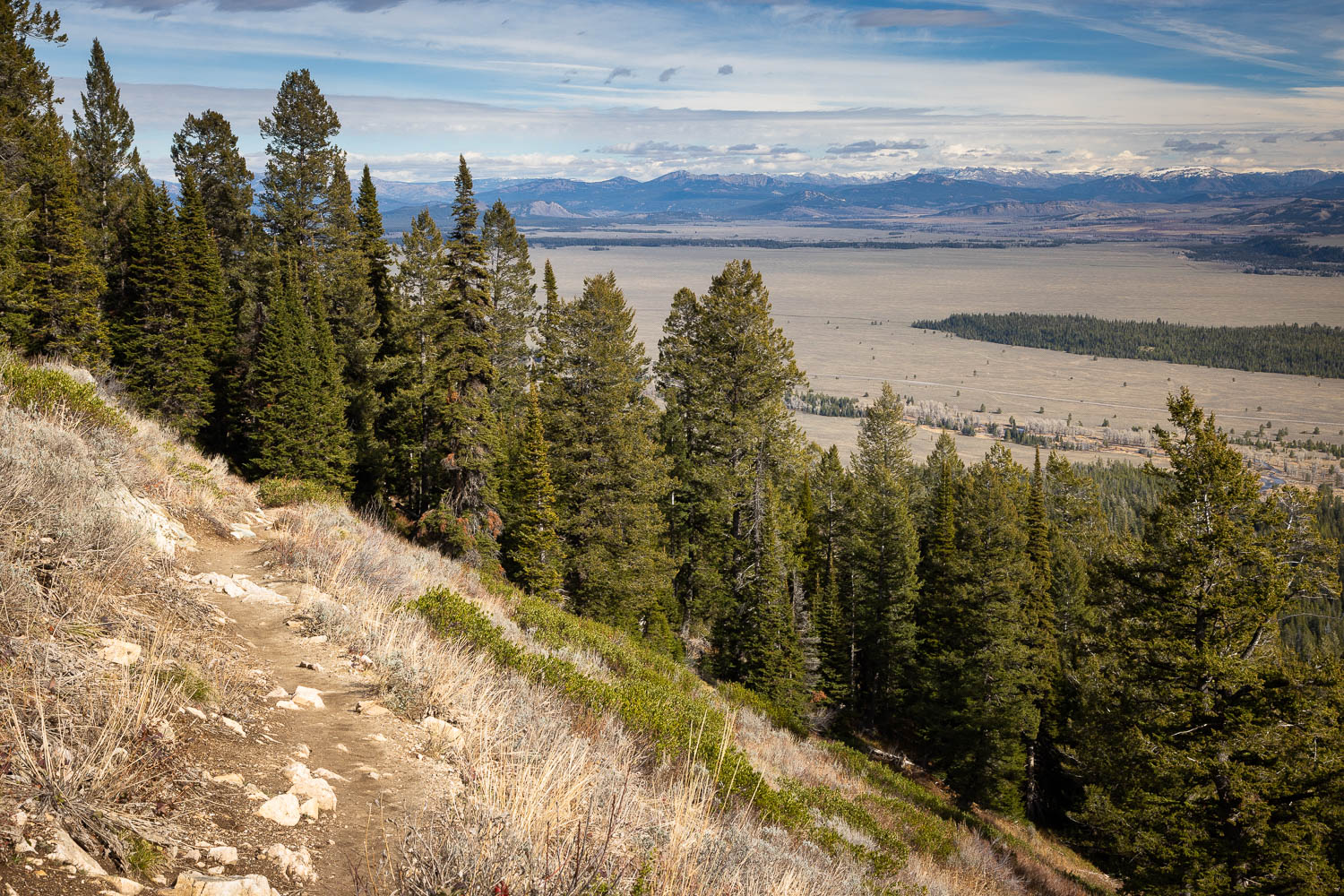
At this point the trail begins a lengthy series of switchbacks totaling just over a mile. Along the way you’re treated to stunning views of the valley of Jackson Hole as the trail steadily climbs up the Teton Mountains. Throughout this area you’ll also notice numerous signs asking you not to shortcut trails. Doing so causes unnecessary erosion to the mountainside, and seriously, you’re climbing a mountain. How many steps are trying to save?
As you ascend higher you’ll begin to notice both Bradley and Taggart Lakes coming into view far below. The trail also alternates between climbing through open mountainside, flooded with wildflowers in the early summer months, and old dense evergreen forests. It makes for a varied and beautiful hike upward to keep your interests piqued on the consistent climb. Be on the lookout as well through the area for mule deer, black bear, marmots, and more, all of which are frequently seen throughout trail.
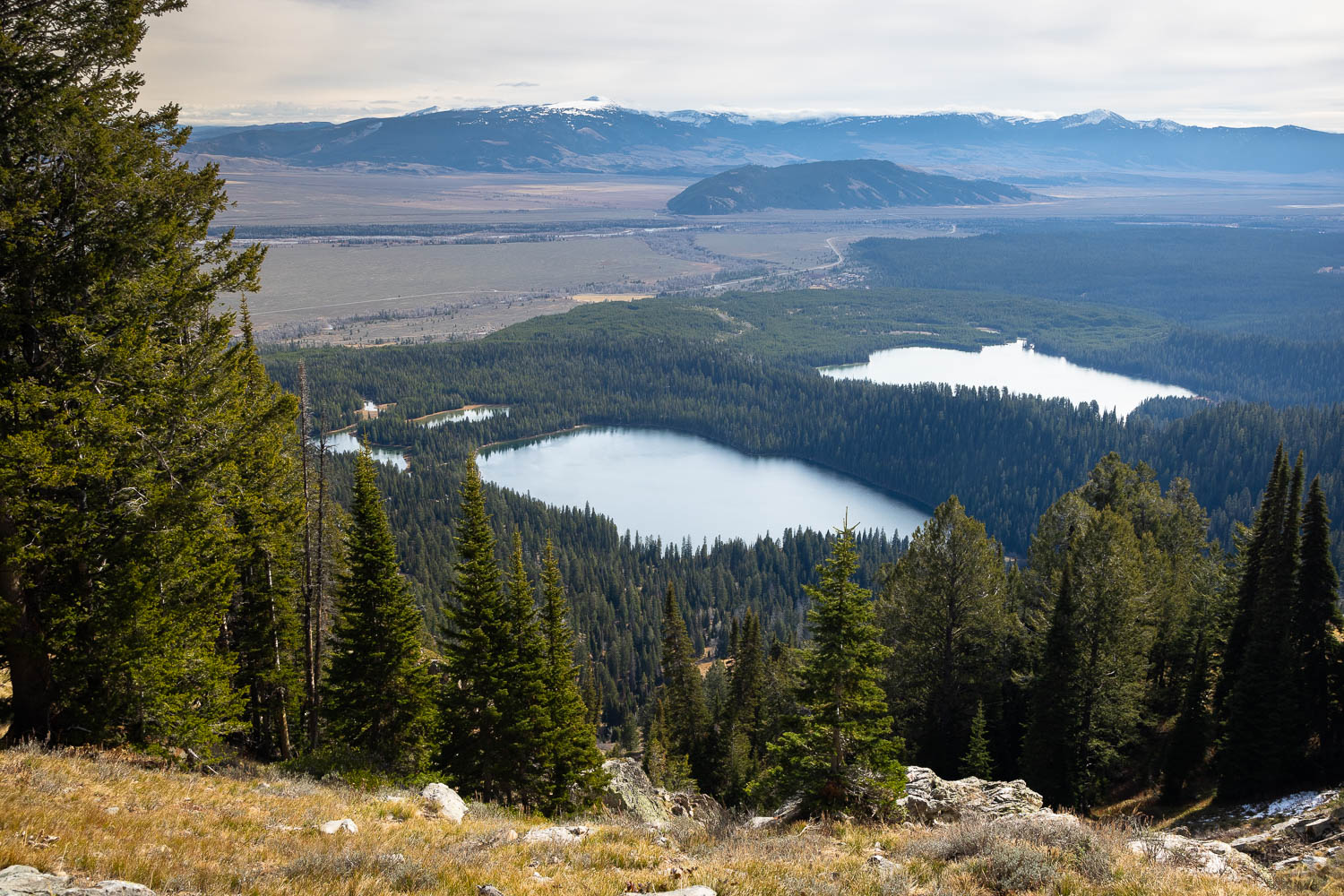
At the top of the switchbacks and at 3.5 miles in, you’ll reach the next junction, where right will bring you to Amphitheater Lake and left will continue to Garnet Canyon. With impressive views of Bradley and Taggart Lakes now far below, the Garnet Canyon Trail continues to gradually climb before taking a break a short distance beyond. A slight descent winds you into Garnet Canyon as it wraps around the base of Disappointment Peak, where the sounds of the creek come rushing from far below.
Gradually descending through the trees, the Garnet Canyon Trail opens up into a massive view of Nez Perce and the Middle Teton, dominating the horizon. It’s about here that you’ll notice a large black stripe running vertically up the middle of the Middle Teton. Long before the Tetons rose, these rocks were ,of course, all underground. A crack in the rocks was filled in with molten lava, which ultimately cooled and then rose with the Teton Mountains. The long black vertical stripe is a remarkable example of geology in action.
As you begin gradually ascending once again, the trail becomes noticeably rockier, climbing deeper into the canyon. You’ll reach another small switchback where looking back toward the valley of Jackson Hole, you’ll see Bradley Lake laying below both the Sleeping Indian and Jackson Peak rising high into the distance. As the trail winds back toward Garnet Canyon, it gets a bit steeper where the Middle Teton and Nez Perce still rise ahead. At this point the trail becomes predominantly boulder fields and talus.
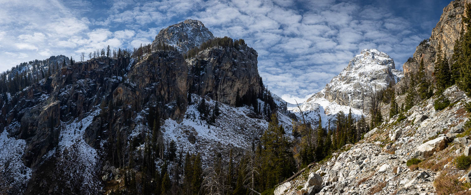
Passing through a grove of evergreen trees, the Garnet Canyon Trail continues climbing through rocks and talus, drawing closer to the creek below as it cascades and rushes over small falls over the rocks. Continue winding over the rocks below the cliffs rising high above where the trail will level out as it reaches a large boulder field. You’ll soon reach a sign marking the Platform Campsites and the Lower Saddle. This is the “official” end of the trail, however most people continue up and over the boulder field to surround themselves by the Grand Teton, Middle Teton, Nez Perce, and Disappointment Peak towering above them like granite skyscrapers. How far you go is up to you, but make sure you know your limits, and head out the same way you came in.
Elevation and route courtesy of Route Scout
Getting There
From Moose, Wyoming, head north on the Teton Park Road for 6.5 miles and turn left at the Lupine Meadows Trailhead junction. Follow that road across Cottonwood Creek and the road will split twice. Head left and then an immediate right, following that road to its terminus where the trail begins at the end of the large parking area (parking permitted).