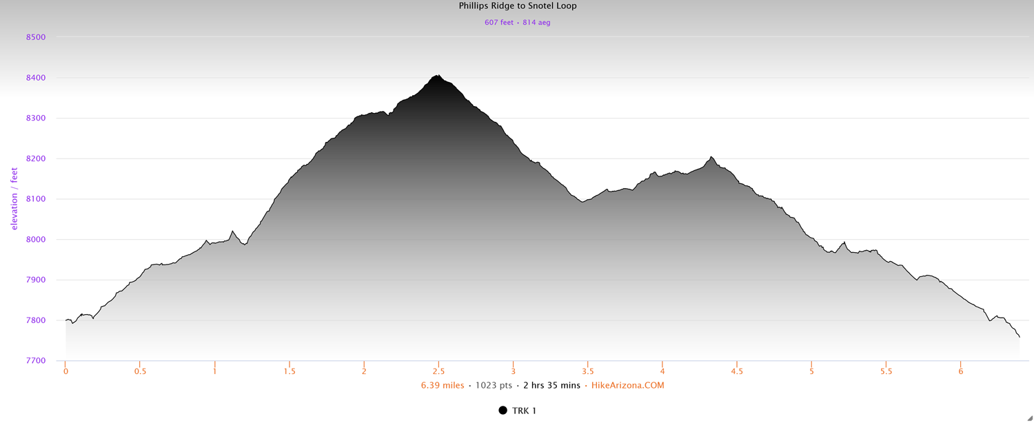
Distance: 6.4 miles
Type: Lollipop loop
Difficulty: Moderate
Kid-friendly: No
Dog-friendly: Yes
Water: No
The Phillips Ridge to Snotel Loop is a great 6.4 mile hike through the southern Teton Mountains, providing intimate forest views with stunning vistas from Phillips Ridge. The moderate lollipop loop can be hiked clockwise or counterclockwise, the former saving the best views for the way out. It makes for a great day-hike for those visiting the Teton Pass area.
Phillips Ridge to Snotel Loop Trail Description
From the Phillips Bench Trailhead, begin heading up the wide dirt road. After making a bend in the road, pass the initial junction on the left and then look for a junction on the right immediately after. Head right to begin up the Arrow Trail. You’ll pass through a lush sparse forest, making a gradual overall incline along the way. You’ll quickly reach a large open meadow with a beautiful view overlooking Highway 22 as it ascends toward Teton Pass.
The trail will bend northward around a ridge where you’ll head deeper into forest groves and rich meadows. The mostly level trail twists and turns into a denser section of forest. At the next junction at 1.2 miles in, head straight (right) to begin up the Phillips Ridge Trail. If you’d prefer to do the loop clockwise, head left. The rest of this post assumes you’re going right. You’ll climb through a thin forest, soon passing under large power lines. Continue climbing up through the forest where you’ll notice the terrain becoming a bit rockier as you approach the crest. You’ll then make a few quick switchbacks up to the ridgeline of Phillips Ridge.
The views eastward begin to open up as the Gros Ventre Mountains tower over the valley of Jackson Hole below. A bit farther up, you’ll reach stunning unobstructed views, providing a welcome opportunity to rest and enjoy the view. Continuing up the trail, you’ll traverse below the west side of the ridge as you weave along the ridgeline. Along the way, you’ll pass through an old gate, followed by a picturesque backcountry campsite.
After entering into a lush aspen grove, you’ll make a few small switchbacks up, dotted with large boulders. Cross over a small dirt road where you’re then treated to gorgeous views of the southern Teton Mountains through the thin trees. Another junction awaits just beyond at 2.5 miles in. Head left to begin down the Snotel Trail.
Easy switchbacks will guide you downward, paralleling the nearby power lines. After crossing the dirt road again, you’ll enter into a denser forest. The steady downhill wanders peacefully through the forest. You soon emerge below the power lines where you’ll pass through a junction with the road along with the power lines before heading back into the forest. You’ll peacefully saunter through the woods and meadows where you’ll soon reach another junction at 3.7 miles in. Head left to pick up the Arrow Trail again.
The forest floor will quickly get thicker as you cross a faint road and resume on the single track. Zigging and zagging through the forest, you’ll wander through more forest and meadows, slowly gaining elevation. As the tranquil forest gets thicker, you’ll notice a large meadow on the right visible through the trees. You’ll maintain an easy wander through the woods before cresting over a hill. Once over the hill, you’re treated to views high above the early part of the trail.
An easy meandering descent guides you in and out of the trees and down easy winding switchbacks. The trajectory of the trail may not make a lot of sense in one or two area, but remember it’s also a mountain biking trail. Be sure not to shortcut and cause unnecessary erosion. Even if you only do it once, others will see the depressions in the vegetation as an invitation to go themselves.
Continue dropping through the woods to another junction at 5.1 miles in. Continue straight, crossing the road, and find the next junction almost immediately after. Head right to close out the loop, where you can follow the Arrow Trail back to the trailhead.
Elevation and route courtesy of Route Scout
Getting There
From downtown Wilson, head west on Highway 22 for 3.8 miles. Park at the large parking area on the left opposite the road from the Phillips Bench Trailhead.