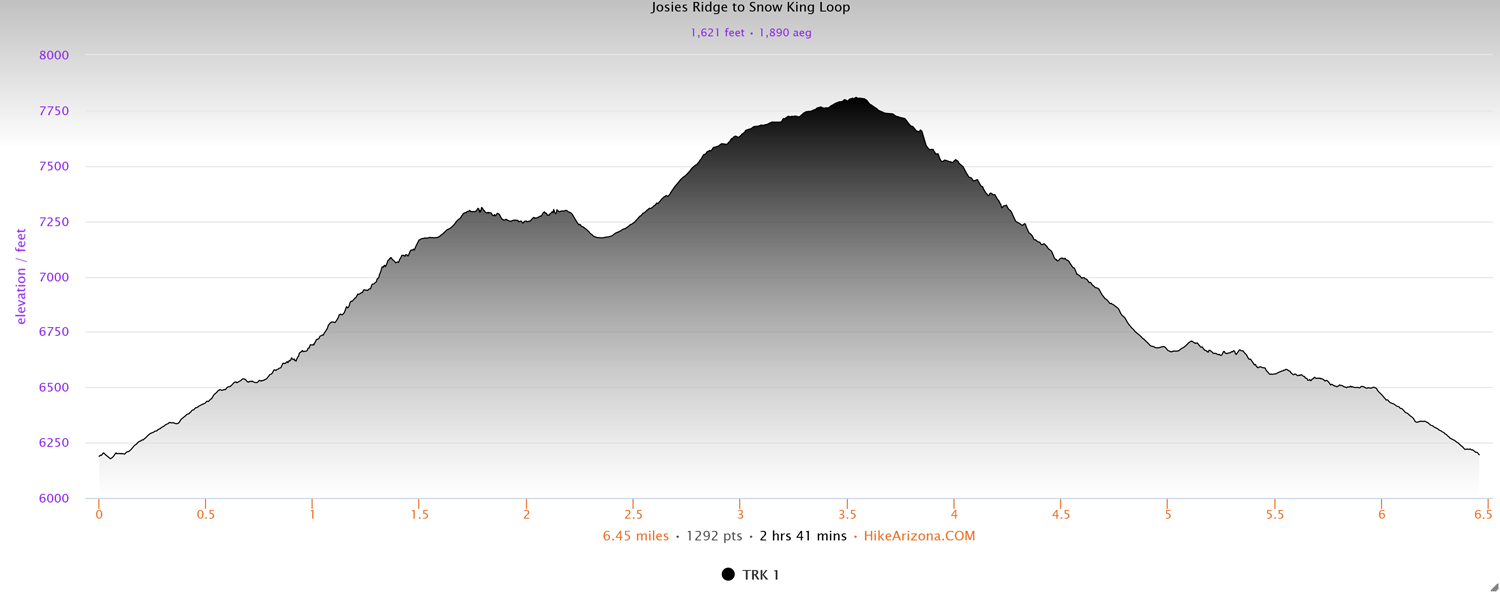
Distance: 6.4 miles
Type: Lollipop loop
Difficulty: Strenuous
Kid-friendly: No
Dog-friendly: Yes
Water: No
Both the Josie’s Ridge trail and the Snow King Summit trail are popular hikes for locals to get above the town of Jackson and the surrounding area. Less popular, but even more impressive, is linking the two trails into one diversely beautiful 6.4 mile loop hike.
The loop can be accessed from a number of locations, which most locals will have no trouble choosing, but for those not familiar with the area, I started from the first access point at Wildlife Lane, at roughly the bottom-center of the loop on the north side of the mountain.
Though either direction will be challenging, the easier route will be to head west (right) as you enter into the main trail system and proceed up toward Josie’s Ridge.
View more images available as prints from the Gros Ventre Mountains
Josie’s Ridge to Snow King Loop Description
Begin the trail by hiking up the hill from the Wildlife Lane Trailhead along Snow King Avenue, where you’ll find yourself hiking between a few homes, as well as some beautiful aspens that welcome you to the trail. Continue through one junction where evergreens begin to break up the aspens, and through another, bringing you onto Linda’s Trail.
As you climb though a large meadow, the nearby road noise merges into one overall town noise, forming a distant white noise hum. Here you’ll switchback through a large sagebrush meadow, and up into a dense lodgepole pine forest that covers much of Snow King Mountain. The trail will level off for a brief moment where Linda’s Trail ends, merging with the Sink or Swim Trail. You can either go right or left at this junction, and either way will allow you to complete the loop. This post however describes the loop beginning to the right, heading up toward Josie’s Ridge.
Both the town of Jackson and the distant Teton Mountains poke out from breaks in the forest as you make a steady, and sometimes steep ascent through the old peaceful forest. The constant urban hum follows you through the next junction, where you’ll continue climbing left on the Sink or Swim Trail.
After a particularly steep section of trail, you emerge in a large hillside meadow with beautiful views over the western side of the town of Jackson. It’s also at this location that the junction for the official Josie’s Ridge Trail is accessed by heading left. Here begins a steep series of switchbacks that ascend up an exposed ridge, constantly overlooking the busyness of town. It’s also strongly encouraged that you not cause extra erosion by shortcutting, so staying on the trail is appreciated by both the forest service, and many locals. After all, you’re climbing a mountain. How much energy are you trying to save?
The trail continues its steep ascent as it gradually begins to enter a sparse forest once again. As the trail begins to clear once more, you’re treated to exceptional views of not only Jackson, but also of the Teton Mountains and Snake River Mountains to the west thanks to the height you’ve climbed up. You’ll make one quick rocky ascent where you’ll reach another junction. Though many people sometimes consider this a satisfying end to the Josie’s Ridge Trail, another trail will begin climbing the literal Josie’s Ridge by heading right.
The final Josie’s Ridge Trail ascends through a forest treeline, skirting the highest ridge separating a forest from high desert. Here it winds up a rocky outcropping, rising high above Leeks Canyon on the left. The trees on your right and the wilderness on your left help to now minimize and drown out the white noise from town. The expansive Gros Ventre Mountains and it’s gorgeously rolling foothills create a window into a primal wilderness, as if you’re far away from any civilization.
Continue up on top of Josie’s Ridge where many admirable spots can be found to enjoy the view, or continue to its end a bit farther where the southern end of the valley of Jackson Hole stretches downward along the Snake River. Here the Snake River Mountains rise up above the valley miles across from you. Behind you is Snow King Mountain and the beautiful lower Gros Ventre Mountains. It makes for a wild and beautiful perch. When you’re ready, head back toward the previous junction where you can either go back out the Josie’s Ridge Trail or continue along the loop.
Back at the junction, continue the loop by heading right and up toward Snow King through a meadow of sagebrush lined with patchy evergreens. You’ll switchback up through more pines before emerging onto a rocky ridge where you’ll begin to gain more elevation. The steep climb wraps around to a vantage point where you can overlook Josie’s Ridge back west, and where you’ll notice the noise from Jackson has all but faded away. As you climb higher above Leeks Canyon, you’ll have spectacular views into lower Jackson Hole, crowned by the mighty and underrated Snake River Mountains.
For those wanting quiet and solitude, this is where the loop shines. It’s a peaceful and calm section of the trail that makes you feel like you’re deep in the mountains. The high desert mountains mingle with the forested mountainsides as cool breezes waft through the air, making you feel like you’re miles away from any town.
You’ll soon reach another saddle where the trail has been rerouted in recent years to wind along the back (south) side of the mountain. The extra peace and quiet from the town noise on the opposite side as Leek’s Canyon comes more into view as you press on. Reaching a sharp bend in the trail, you’ll notice the Snow King Observatory rising above as you enter a small grove of conifer trees. You’ll continue wrapping around the base of the hilltop, catching glimpses of the observatory and a recent restaurant emerging ahead. There are overlooks and platforms here to enjoy, so check out the surroundings and enjoy the views.
When you’ve enjoyed the iconic views that only Snow King can provide, continue eastward on the trail, passing both the Ski Patrol Cabin and the Nature Trail junction. As you begin your way down the initial steep descent, you’re treated to unparalleled views both in front of you, and to your left looking northward.
In front, the overlooked Gros Ventre Mountain peaks shoot up into the sky ahead, rocketing far above the treeline. Looking left to the north, the valley of Jackson Hole stretches out far below and into the horizon. On clear days, the jagged Absaroka Mountains can be seen on the other end of the valley over 40 miles away, the east and west crowned by rolling northern Gros Ventre Mountains and the remarkably beautiful Teton Mountains, respectively.
At a fork in the trail a short distance down, head left, following the ‘Easy’ ski run, where you’ll follow the Snow King Summit Trail most of the way down the mountain, all the while being treated to some of the best views of the valley the area has to offer. Directly below you all along the way is one of the grandest views of the town of Jackson you’ll find anywhere, as Highway 89 reaches into the northern parts of the valley, sandwiched between East Gros Ventre Butte and the National Elk Refuge.
Switchback after steep switchback drops you down closer and closer to the valley, but with roughly a third of the way still to go down, you’ll reach the junction for the Sink or Swim Trail once again as you pass through a large junction of ski runs while heading west. The trail will rise slightly higher as you pass below the Cougar Ski Lift before it drops back down as you near the forest and then enter back into it.
Despite the urban noise that you’ve come back into close proximity to, there’s a quiet peacefulness thanks to the forest as the trail bobs up and down through the old trees. Continue along Sink or Swim, passing through three junctions, the final being KC’s Trail. The Sink or Swim Trail will open up into a large meadow shortly after, where you’ll reconnect with Linda’s Trail on the other side. Follow Linda’s Trail out, heading back toward the Wildlife Lane forest access trailhead.
Elevation and route courtesy of Route Scout
Getting There
From downtown Jackson, head south on Cache Street for 0.5 miles, turning right onto Snow King Avenue. Continue for 0.7 miles, and just before crossing over Flat Creek, turn left into the Wildlife Lane Trailhead.