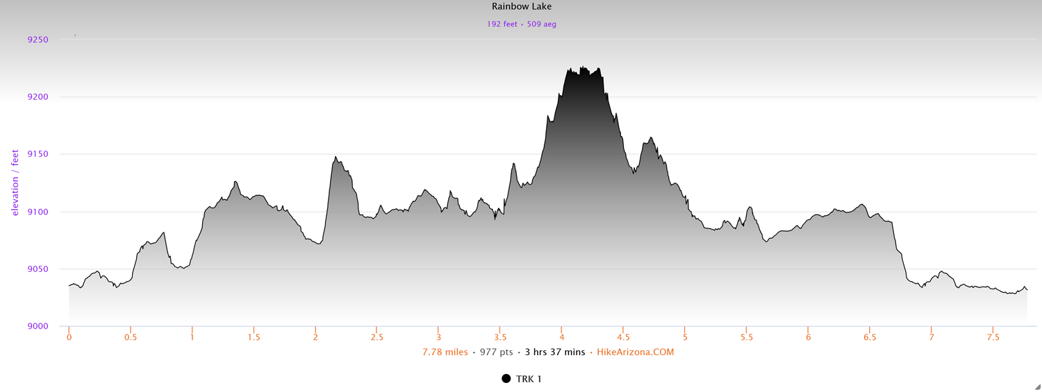
Distance: 7.8 miles
Type: Lollipop loop
Difficulty: Moderate
Kid-friendly: No
Dog-friendly: Yes
Water: Yes
The hike to Rainbow Lake and Upper Brooks Lake is a remarkably peaceful saunter through a small but wide valley in the southern Absaroka Mountains in the Shoshone National Forest. The 7.8 mile trek has a bit of elevation change from time to time, especially heading up to Rainbow Lake, making it a moderate hike. In addition, the tranquility of the area and the wetlands along the route, plus the towering pinnacle peaks, make it a rewarding day out.
Rainbow Lake and Upper Brooks Lake Trail Description
Staring from the west side of Brooks Lake, hike north along the trail as it wanders through willows and over an occasional footbridge. After a noticeably longer footbridge, you’ll reach an unsigned fork in the trail where you’ll want to head right. This trail will fork into several parallel trails. There’s no right or wrong path to take, they all continue to the same place, each wrapping around the north end of Brooks Lake.
The trails soon begin to merge and veer north from the lake. You ascend up a small pass and an immense valley opens up in front of you. Large pinnacle peaks line the east side while a dense forested hill blankets the west. Directly ahead the wide valley is shallow and lush and dotted with wetlands throughout. You’ll follow the trail north as it bends to the east side of the valley. You’ll soon reach a partially signed fork. Left will head to Jade Lakes, so continue straight (right).
Continuing up the east side of the valley, you’ll cross a creek where you can find a makeshift footbridge just off to the right. On the other side of the creek, you’ll make a short but steep ascent up a hillside. Once at the top, the trail will level out as it wanders through the edge of the forest. It doesn’t take long to emerge from the forest where you proceed along the eastern edge of wetlands. It’s here that you’ll notice the valley beginning to narrow as well.
Shortly after you’ll reach another unsigned fork. Head left where you’ll maintain a northerly direction. Not long after, you’ll begin to see Upper Brooks Lake popping into view above the willows. The trail wraps around the east shore of the lake as you reach a discrete, unsigned fork. Head left, where you’ll loop around the north end of the lake, providing stunning views of the tranquil body of water.
On the opposite side, you’ll climb steeply into the woods, followed by a signed fork to access Rainbow Lake. Head right to begin up toward the second lake. You’ll ascend up along a creek, soon veering away from the rushing creek to follow a smaller creek. As you make a more gradual ascent up, Rainbow Lake appears over a small pass. The sprawling lake is surrounded by forest as peaks rise up in the distance. If you follow the trail along its shores, you’ll even find a backcountry camp site ahead, also providing more gorgeous lake views.
Once you’ve enjoyed the views to your satisfaction, head back out to the previous junction, and proceed right to head back toward the trailhead. You’ll make a number of short ascents and descents through the forest edge, while also catching glimpses of Upper Brooks Lake through the trees. The trail will continue wandering through the forest then emerge into the open valley. Now on the west side, you’ll meander along the treeline bordering the wetlands before reaching a signed junction for the Jade Lakes and Upper Brooks Lake. Head left down the slight descent.
The trail will begin cutting across the open expanse, leaving most of the wetlands behind. After a quick and easy creek crossing, you’ll connect with the original fork. Continue heading straight (south) where you’ll follow your original route back to Lower Brooks Lake and back to the trailhead.
Elevation and route courtesy of Route Scout
Getting There
From the Moose Junction in Grand Teton National Park, head north on Highway 89 for 43.6 miles. Be sure to continue straight through the town of Moran, passing the Moran entrance station to Grand Teton National Park and the main route to Yellowstone. Instead, continue toward Dubois. The turn for Brooks Lake Lodge and Campground will be signed, and you’ll make a left turn there. Follow the road for 4.6 miles where, just before you reach the lodge, you’ll turn right to descend toward the Brooks Lake Campground. Proceed straight past the campground and just past the boat launch you’ll see the trailhead.