Distance: 5.25 miles (one way)
Type: Out and back
Difficulty: Strenuous
Kid-friendly: No
Dog-friendly: Yes
Water: Yes
The Jackson Peak hike is a 5.25 mile (one way) trek and is a fantastic intro into climbing one of the peaks surrounding Jackson Hole. From within the valley, it’s one of the relatively easier climbs that give you significant altitude, providing a stunning vista from its summit. At approximately 10.5 miles round trip, along with a serene glacial lake along the way, it makes for an excellent day hike.
View more images available as prints from the Gros Ventre Mountains
Jackson Peak Trail Description
The Jackson Peak hike can be broken down into five segments that seem to correlate with each mile. The first mile, much like the last, is one of the hardest, though in terms of relative difficulty, not very hard. The trail begins a steep ascent through the sparse woods, soon climbing through a wide pristine meadow. The ascent continues, rarely letting up as you reach the opposite side of the meadow and enter a thicker and denser forest. Zigzagging through the predominantly lodgepole pine forest, you gain significant elevation before reaching a ridgeline that extends from the northeast arm of Jackson Peak.
Once upon the ridge, approximately 1 mile in, the trail’s steepness begins to subside. Though still gaining elevation, it comes much more gradually as you occasionally pop out into a meadow that straddles the ridgeline. The views are still fairly limited though, with the only real scenery coming from across the canyon to the east, when you have a view. This becomes a familiar theme throughout the second mile, where a dense forest gives way to a pleasant meadow, and you peer across the canyon.
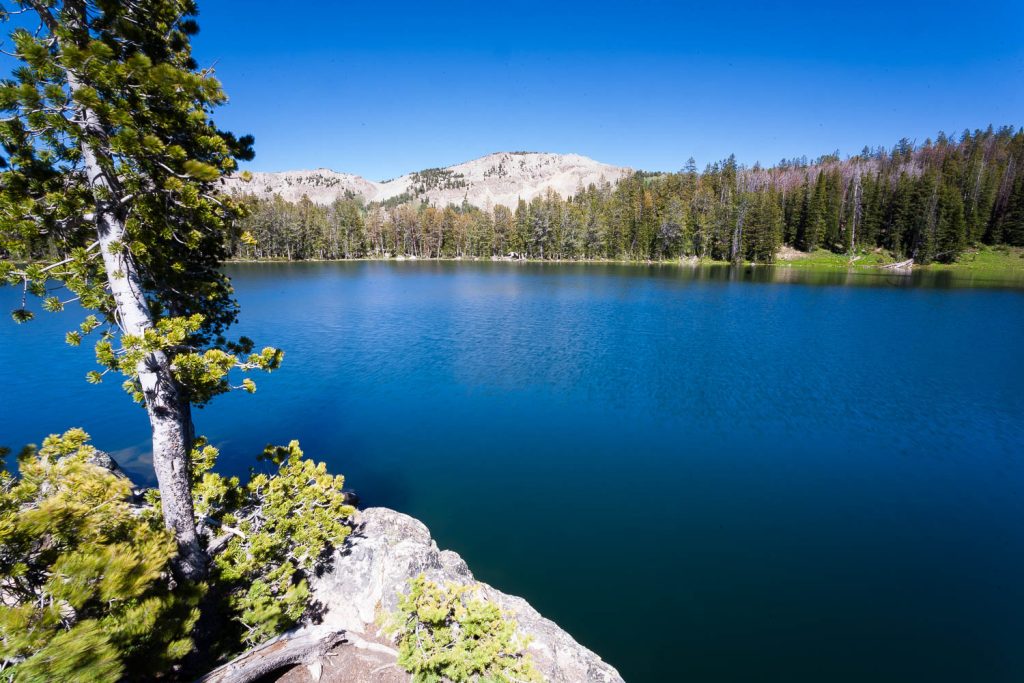
At roughly three miles in, you reach the Gros Ventre Wilderness boundary. From here, the ridgeline you were hiking along ascends up at a much steeper rate toward Jackson Peak, while the trail veers left along the side of the ridge. Soon the trail becomes rockier, the trail winding along the occasional talus field where a pika can potentially be heard calling out. Though still gradual, the elevation continues to add up as you begin to hear the sound of rushing water getting closer. After a short climb back into the woods, you reach running water, pouring out of Goodwin Lake just a short distance ahead.
Though you can follow the trail around either side of the lake, the official trail heads left where a sign stands above the creek, inviting hikers to make an easy hop across and continue onward past some campsites. The campsites are first-come, first-served, so if you’d like to turn this into an overnight hike, the option is there.
Along the way as you’re passing the campsites, the eastern flank of Jackson Peak shoots out of the western side of the lake in a massive talus field that reaches skyward. While not as grand as you might expect, the views are still both serene and calming. It’s the kind of alpine glacial lake that inspires more peace and tranquility than raw bold adventure.
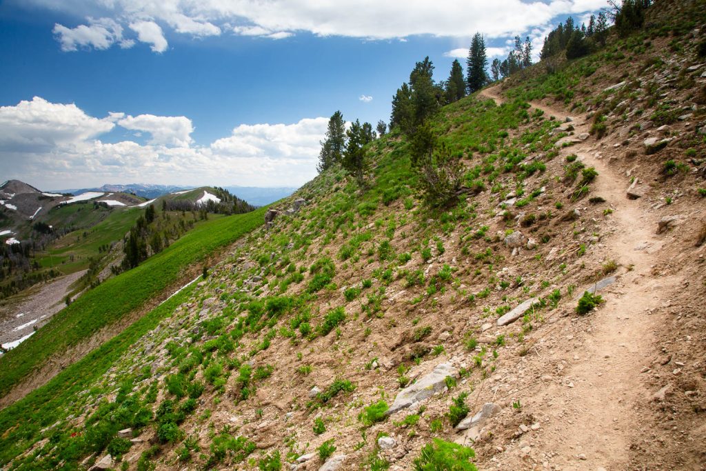
Following the trail past the lake, you’ll quickly ascend, where it soon begins to emerge from the forest and out into alpine meadows, the trees thinning as you begin to near the treeline. This is roughly where mile 4 starts.
Though the climb out from the lake is short, you still begin to gain a bit more elevation again as the trees thin out, opening up into wide and vast alpine meadows. There’s plenty of exposure here, and it will only increase as you near the summit. You’ll pass an occasional pool, depending on when in the season you’re hiking, before reaching the final mile which is marked by a fork in the trail. Straight continues deeper into the Gros Ventre Wilderness, right begins the ascent of Jackson Peak.
This last mile will be the hardest, partly because it’s one of the two steepest miles in the hike, and partly because you’ve already been hiking uphill for four miles. As you begin up the summit trail, the rocky slopes will become more common while the trees will become more sporadic. When there are trees, they’ll be smaller and wind blown, reflective of the harsh weather they endure. The trail gradually wraps around the southeast side of the peak, before finding a ridge to begin climbing up toward the summit. Along the way, trees become even less common as the trail becomes rockier while ramping up the elevation change.
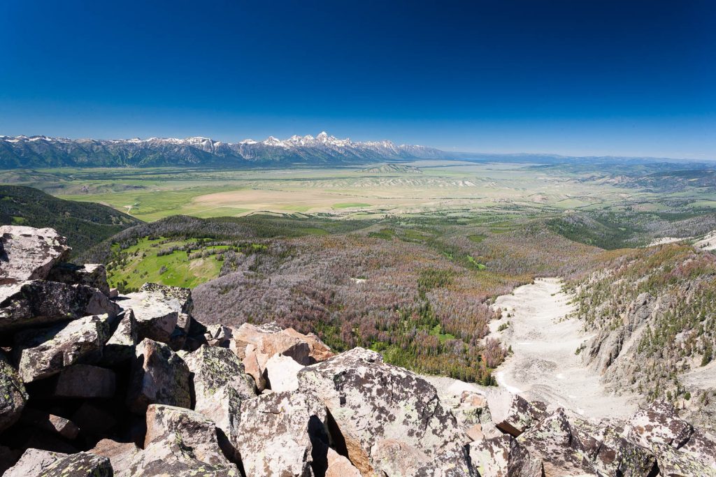
Soon only a few small trees dot the sides of the trail as you ascend onto a rocky ridgeline, one false summit after another making you think you’re closer to the end than you are. Finally you crest one last false summit and the end is in sight, straight ahead with a relatively small amount of elevation to gain. From here, it’s an easy jaunt to Jackson Peak where a massive cairn awaits, giving you the opportunity to stare deep into the valley of Jackson Hole and beyond. Enjoy this view as long as you’d like, and head back out the way you came.

Elevation and route courtesy of Route Scout
Getting There
From Town Square in Jackson, Wyoming, head east on Broadway for about a mile until it dead-ends at the National Elk Refuge. Turn into the National Elk Refuge and follow the road for about 5 miles, where you’ll pass through a small subdivision before turning right onto Curtis Canyon Road. Head up the rough dirt road for about 2.6 miles and look for a fork on your right, which is Sheep Creek Road, otherwise known as Forest Road 30440. This road can be very rough, so high clearance beyond this point is strongly recommended. For this reason, many people choose to park at the fork and walk up from there. This will add about another mile each way to your trip. If you want to head up the road, follow it for about another mile or so and the trail will begin at the Goodwin Lake Trailhead where the road dead-ends.