
Distance: 8.6 miles (one way)
Type: Out and back
Difficulty: Strenuous
Kid-friendly: No
Dog-friendly: No
Water: Yes
The Paintbrush Divide is a strenuous 8.6 mile hike up to one of the most stunning mountain divides in the Teton Mountains. Taking place entirely within Grand Teton National Park, the trek wanders past two stunning glacial lakes as it ascends well beyond treeline, climbing nearly 4,000 vertical feet.
Paintbrush Divide Trail Description
String Lake Loop
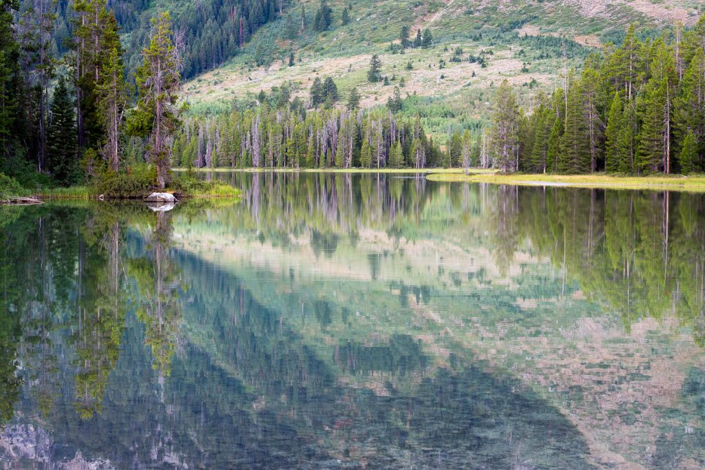
From the Leigh Lake Trailhead, head north along the eastern shore of String Lake. This gorgeous glacial lake provides ample opportunity to admire the Teton Mountains before reaching Paintbrush Canyon.
Twisting and turning along the shore, you’ll reach a junction after 0.9 miles. Proceed left, where you’ll quickly reach another junction. Head left again to cross the large footbridge. This bridge safely guides you across the runoff from nearby Leigh Lake as it feeds String Lake. In addition, it marks yet another stunning vantage point.
On the other side of the bridge, the trail snakes through the forest, soon gaining elevation, sometimes at a steep pace. After one steep stretch, a small pond can be seen below on the left. Continue ahead where you’ll ascend through a meadow and back into the woods. At 1.7 miles in, you’ll reach the junction with the Paintbrush Canyon Trail. Proceed right and continue climbing as you approach the mouth of the canyon.
Lower Paintbrush Canyon
As you wrap around the base of Rockchuck Peak, the trail will soon smooth out, allowing for some easy hiking as you slowly begin to enter the canyon. Continue ascending where, at 3.5 miles in, you’ll reach a scenic forest overlook with Paintbrush Creek roaring below. A short distance beyond and you’ll notice you’ve reached the Lower Paintbrush Camping Zone. A campsite in this area would be a great way to lessen the distance of the hike, but be sure to secure a permit if you want to consider that option.

Heading steadily through the camping zone, you’ll reach a large clearing in the canyon where the first significant views unfold. In moments, panoramic views with immense granite cliffs towering around you dominate the scenery. As waterfalls pour over the cliffs, you soon reach a pair of switchbacks, guiding you higher. On the opposite canyon wall, a gorgeous waterfall pours thousands of feet down.
You’ll consistently climb higher and higher through exposed canyon walls, adorned with lush cascading creeks pouring toward the center of the canyon. A thin forest awaits as you ascend higher, many of the trees the endangered whitebark pine. A series of switchbacks then helps you gain more elevation before reaching a long, grueling straightaway, a junction waiting at the end, 6.2 miles in.
Upper Paintbrush Canyon
There isn’t a right or wrong direction to go – each will reconnect roughly 1 mile up the trail, depending on which direction you go. If you’re doing this as an out and back, pick one to take up, and follow the other back down. Heading right will wander past Holly Lake, one of the highlights of the trail, so this write-up will follow that. On the way back, taking the other trail, there are no significant landmarks, but there is astounding alpine beauty to behold.
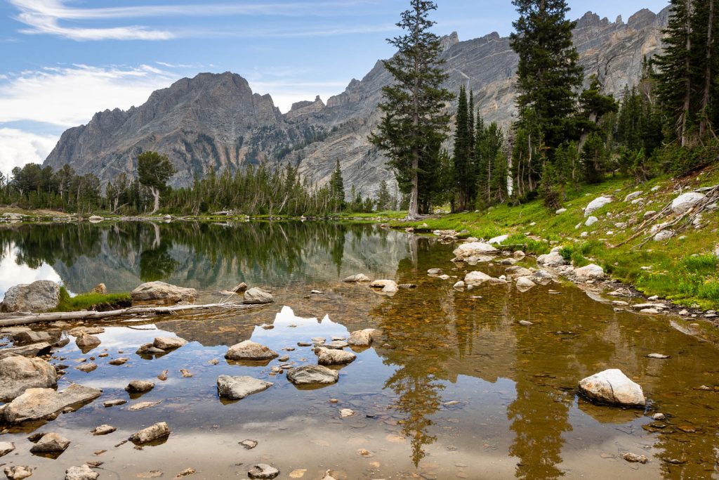
Following the trail right from the junction, you’ll shortly notice a large snow-melt pond just beyond the trail. Check it out at your leisure, but please be conscious of the fragile alpine vegetation growing. Continuing up the trail, you’ll cross a creek, then follow another through the thin woods, passing a group campsite on the left. Before too long at all, you emerge from the forest at the shores of Holly Lake at 6.75 miles.
Enjoy the views as long as you’d like, and when ready, proceed back onto the trail and head up the steep incline. Ascending from Holly Lake, the trees will get noticeably thinner as you begin to reach treeline. Crystal clear streams trickle nearby as rock overtakes dirt. The higher you climb, the smaller the vegetation gets. As the vegetation is barely clinging on, you’ll notice off to the right a captivating view down into Leigh Canyon to the north. Clearly visible are the Grizzly Lakes in the upper reaches of the canyon.
Ascending the Paintbrush Divide
Beyond the view of the lakes, you’ll round a ridge and the vegetation will completely disappear. In its place is all rocky talus and steep cliffs. If you’re attempting this hike before mid-July, it’s highly recommended you bring ice axes and crampons for this next section. Snow will linger along this stretch well into summer and one misstep could end in tragedy. Even in summer, it has the potential to give those with a fear of heights pause.

At the other end is a rocky wall with large, steep steps built into the cliff. While steep as well, there’s at least something to hold onto here. After hauling yourself up the switchback steps, the trail will flatten out, and a short distance beyond a discrete sign will mark the Paintbrush Divide, at over 10,700 feet above sea level.
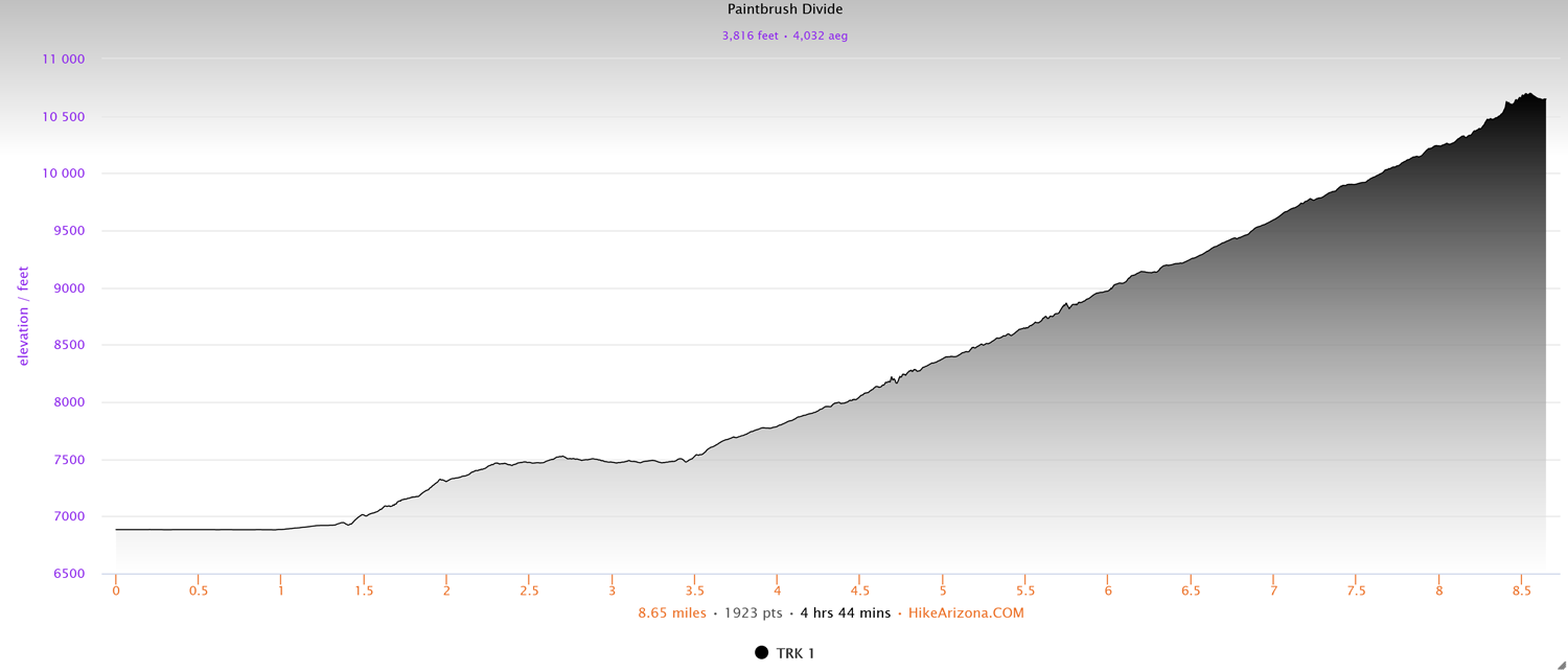
Elevation and route courtesy of Route Scout
Getting There
From the Craig Thomas Visitor Center in the town of Moose, head north on the Teton Park Road for 10.2 miles, passing through the Moose Entrance Station. Turn left at the North Jenny Lake Junction and follow that for 1.5 miles. At the 4-way junction, turn right and follow that road to the large parking area at the end. The trailhead will be at the northwest end of the parking lot.